
Source
[XCVario]
[External]

For wind calculation using “XCVario” source, the wind is calculated during circling. The procedure is straightforward, the calculation relies entirely on GPS data so a Flarm or other GPS source is necessary. During the calculation, the ground speed vectors are analyzed, and the wind vector is determined from the directions corresponding to maximum and minimum ground speeds.
The method is effective even if the circles are not perfectly circular, though maintaining a relatively constant speed while circling improves accuracy.
Measurement quality is further enhanced through intelligent filtering, which incorporates a quality factor based on the correlation between the directions of minimum and maximum ground speeds. Typically, two to three circles are sufficient for an accurate wind measurement, while an initial wind estimate is available after just one circle.
With the “External” setting the wind calculation from an external device like the anemoi. Have a look at anemoi live wind indication
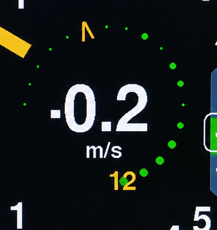
The live wind indication is overlayed to the thermal assistant, when circling, else it is displayed on top of a wind rose at the same place. Indication is split into the wind strength rounded to e.g. km/h, and an arrow tip on the opposite side on the rose.
Anemoi live wind display showing 12km/h from ca. behind.
Reference
[Heading-Up]
[North-Up]

Display the wind arrow indicator either relative to your heading, means relative to the body of your plane, or relative to “North-Up”, means the wind is displayed relative to north on top of the Indicator. The default is “Heading-Up”, that means indication is plane relative.


